 |
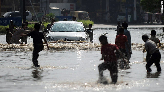
| Pakistani youths play in a flooded street after heavy rains in Karachi on September 11, 2011 (CNN) -- U.N. aid agencies are assisting in relief efforts in southeastern Pakistan after flooding caused by heavy rains killed almost 200 people and destroyed or damaged more than one million homes, the United Nations said.About 200,000 people have been displaced by the flooding and need immediate assistance, the U.N. Office for the Coordination of Humanitarian Affairs said in a statement released Saturday. Joint U.N.-Pakistani teams are on the ground in the region to assess the damage, said Timo Pakkala, the U.N. Humanitarian Coordinator in Pakistan. Torrential rains during the annual monsoon season have inundated an estimated 4.2 million acres of land, the U.N. said. |
Monday, 12 September 2011
Pakistan flooding kills 200, damages almost 1 million homes, U.N. says

BBC News - India probes child HIV cases after blood transfusions

An investigation has been launched into how 23 children who received regular blood transfusions have tested positive for HIV in the Indian state of Gujarat.

The children suffer from thalassaemia and get their blood transfusions at a public hospital in Junagadh district.
Hospital authorities have denied that the children were infected by their blood supplies.
But state authorities have launched a probe after routine tests of nearly 100 children revealed the latest cases.
About 2.5m people in India have the HIV virus, according to UN-backed government figures. Gujarat, along with Bihar and Uttar Pradesh, account for 22% of HIV infections in India.
The 23 infected children in the latest case are aged between five and 10 years.
They showed positive for HIV following recent tests of nearly 100 children suffering from thalassaemia and who receive blood transfusions at the hospital twice a week.
Gujarat Health Minister Jay Narayan Vyas said that the children may have been infected after receiving transfusions "at some other places".
He also said some pre-transfusion tests at the hospital had found that the children already had HIV.
But the parents of the infected children insist that they only ever got transfusions at the Junagadh government hospital.
"We have never gone anywhere else [for blood transfusions]. How can they (authorities) say that children were affected with the virus before getting registered?," Salim Sheikh, the father of one child, told The Indian Express newspaper.
Indian authorities say the number of annual new HIV infections has declined by more than 50% during the last decade.

BBC News - France nuclear: Marcoule site blast kills one
One person has been killed and four injured, one seriously, by a blast at the Marcoule nuclear site in France.

There was no risk of a radioactive leak after the blast, caused by a fire near a furnace in the Centraco radioactive waste storage site, said officials.
The plant's owner, national electricity provider EDF, said it had been "an industrial accident, not a nuclear accident".
There are no nuclear reactors at the southern French site.
The explosion hit the area at 11:45 local time (09:45 GMT).
"For the time being nothing has made it outside," said a spokesman for France's Atomic Energy Commission (CEA).
The Centraco treatment centre belongs to a subsidiary of EDF. It produces MOX fuel, which recycles plutonium from nuclear weapons.
The EDF spokesman said the furnace affected had been burning contaminated waste, including fuels, tools and clothing which had been used in nuclear energy production.
"The fire caused by the explosion was under control," he said.
The International Atomic Energy Agency (IAEA) said it was in touch with the French authorities to learn more about the nature of the explosion.
Director General Yukiya Amano said the organisation's incident centre had been "immediately activated", Reuters reports.
Nuclear power meets 75% of France's energy needs.
Marcoule was opened in 1955 and is one of France's oldest nuclear sites, though it has been extensively modernised.
It is located in the Gard department in Languedoc-Roussillon region, near France's Mediterranean coast.
All the country's 58 nuclear reactors have been put through stress tests in recent months, following the disaster at Japan's Fukushima nuclear plant which was hit by an earthquake and tsunami.
EDF's share prices fell by more than 6% as news of the blast emerged.
-------------------------------------------------
Analysis

The French nuclear programme does not have a stellar record of transparency. In environmental circles, particular opprobrium is reserved for officials who in 1986 claimed the Chernobyl accident would have no impact on France - a statement lampooned as indicating officials believed radioactive fallout observed national boundaries.
What this incident implies for the future of the French nuclear programme is not entirely clear. If it remains a relatively minor matter, it will probably be passed off as the type of thing that regrettably happens in all types of industrial facility.
However, Marcoule is on the list of candidate sites to host one of the European Pressurised Water Reactors (EPRs) that according to government policy are to provide the next generation of French citizens with nuclear electricity.
Friday, 2 September 2011
the photosss of the day :) (national geographic)

Blacktip Shark
Photograph by Brian J. Skerry, National Geographic
The fin of a blacktip shark slices the water's surface.

Polar Bear, Canada
Photograph by Norbert Rosing, National Geographic
A polar bear sleeps on the ice in Canada.

SEPTEMBER 2, 2011
Easter Procession, Spain
Photograph by Carolina Sanchez Monge, My Shot

Congo Family, Republic of the Congo
Photograph by Michael Nichols, National Geographic

Archeï Oasis, Chad
Photograph by George Steinmetz, National Geographic
August 23, 2006
Knee-deep wading is bliss for camels in Chad's Archeï, a canyon whose trapped waters hold a zoological surprise. Fertilized by beasts' droppings, algae are eaten by fish that are preyed upon by an isolated group of crocodiles.
Monday, 22 August 2011
Energy insecurity in China
China is getting more reliant on energy imports despite efforts to switch to a low-carbon economy. This becomes apparent when looking at current data in terms of oil consumption and imports; both increased in the first five months of 2011 as compared to 2010.
In detail, China consumed 10.3% more oil in the first five months of 2011 that it had during the same time period in 2010 and oil imports rose 11.3% in the same time span, pushing China’s dependence on imported oil to 55.2%.

According to the Ministry of Industry and Information (MIIT) China’s oil dependence was only 33% in 2009. China’s economic development has largely relied on energy-intensive industries, and World bank data shows this fact clearly in plain numbers. Between 2006 and 2008, China’s GDP per unit of energy use (Purchasing power parity GDP per kilogram of oil equivalent of energy use) has increased from3.3 (2006) to 3.5 (2007) to 3.6 (2008). To understand how energy intensive China’s economy is one only needs to look at other countries, for example Denmark,where GDP per unit of energy use is 9.9 in 2008. Startling is also what Hong Kong SAR, China, achieves: 19.5 (2006) 19.3 (2007) 20.0 (2008) GDP per unit of energy use.
This data indicates very plainly that an increase of GDP in China is dependent on a lot more (fossil) energy as compared to other national economies. “China is witnessing growing need of crude oil during its development of urbanization and industrialization,” said Tong Xiaoguang, a researcher with Chinese Academy of Engineering. Tong also predicts an further increase of China’s dependence on imported oil, which could reach 60% by 2020 and 65% by 2030.

The problem with this is that a country relying so heavily on imported energy for its growth is vulnerable to oil price fluctuations and shortages. This is part of the reason why China is really pushing for the exploitation of all renewable energy sources within its boundaries. If China wants to reduce its energy insecurity without increasing the national energy mix’ share of coal, it needs to accelerate the development of renewable energy technologies. But this alone will not be enough; China also needs to de-couple economic growth from oil consumption. A shift towards a low-carbon economy consists from several measures, one of them being energy efficiency, especially in the industry. Also a better educated population will aim to work in fields such as services, trade, finances and tourism and thus create value without high energy consumption. At the end of day a share of China’s huge workforce will stay in the industry and there really is no way around a more efficient, more conscious use of imported, fossil energy.
Decoupling economic growth from energy consumption has many benefits, some of them being a less polluted environment and better health prospects as well as the creation of more quality jobs and more (energy) security. It is also an important step towards climate change mitigation.
NASA Mars Rover Arrives at New Site on Martian Surface
NASA Mars Rover Arrives at New Site on Martian Surface
08.10.11
 West Rim of Endeavour Crater on Mars
Image Credit: NASA/JPL-Caltech/Cornell/ASU
 West Rim of Endeavour Crater on Mars (False Color)
Image Credit: NASA/JPL-Caltech/Cornell/ASU
 Arrival at 'Spirit Point' by Mars Rover Opportunity
Image Credit: NASA/JPL-Caltech/Cornell/ASU
 Small 'Odyssey' Crater on Rim of Huge 'Endeavour' Crater
Image Credit: NASA/JPL-Caltech/Cornell/ASU After a journey of almost three years, NASA’s Mars Exploration Rover Opportunity has reached the Red Planet’s Endeavour crater to study rocks never seen before.
On Aug. 9, the golf cart-sized rover relayed its arrival at a location named Spirit Point on the crater’s rim. Opportunity drove approximately 13 miles (21 kilometers) after climbing out of the Victoria crater.
“NASA is continuing to write remarkable chapters in our nation’s story of exploration with discoveries on Mars and trips to an array of challenging new destinations,” NASA Administrator Charles Bolden said. “Opportunity’s findings and data from the upcoming Mars Science Laboratory will play a key role in making possible future human missions to Mars and other places where humans have not yet been.”
Endeavour crater, which is more than 25 times wider than Victoria crater, is 14 miles (22 kilometers) in diameter. At Endeavour, scientists expect to see much older rocks and terrains than those examined by Opportunity during its first seven years on Mars. Endeavour became a tantalizing destination after NASA’s Mars Reconnaissance Orbiter detected clay minerals that may have formed in an early warmer and wetter period.
“We're soon going to get the opportunity to sample a rock type the rovers haven't seen yet,” said Matthew Golombek, Mars Exploration Rover science team member, at NASA’s Jet Propulsion Laboratory (JPL) in Pasadena, Calif. “Clay minerals form in wet conditions so we may learn about a potentially habitable environment that appears to have been very different from those responsible for the rocks comprising the plains.”
The name Spirit Point informally commemorates Opportunity’s twin rover, which stopped communicating in March 2010. Spirit's mission officially concluded in May.
“Our arrival at this destination is a reminder that these rovers have continued far beyond the original three-month mission,” said John Callas, Mars Exploration Rover project manager at JPL.
NASA's Mars Reconnaissance Orbiter, which launched Aug. 12, 2005, is searching for evidence that water persisted on the Martian surface for a long period of time. Other Mars missions have shown water flowed across the surface in the planet's history, but scientists have not determined if water remained long enough to provide a habitat for life.
NASA launched the Mars rovers Spirit and Opportunity in the summer of 2003. Both completed their three-month prime missions in April 2004 and continued years of extended operations. They made important discoveries about wet environments on ancient Mars that may have been favorable for supporting microbial life.
JPL manages the Mars Exploration Rover Project for NASA’s Science Mission Directorate in Washington.
Tohoku Tsunami Created Icebergs In Antarctica
Tohoku Tsunami Created Icebergs In Antarctica
08.08.11
A NASA scientist and her colleagues were able to observe for the first time the power of an earthquake and tsunami to break off large icebergs a hemisphere away.
Kelly Brunt, a cryosphere specialist at Goddard Space Flight Center, Greenbelt, Md., and colleagues were able to link the calving of icebergs from the Sulzberger Ice Shelf in Antarctica following the Tohoku Tsunami, which originated with an earthquake off the coast of Japan in March 2011. The finding, detailed in a paper published online today in the Journal of Glaciology, marks the first direct observation of such a connection between tsunamis and icebergs.
The birth of an iceberg can come about in any number of ways. Often, scientists will see the towering, frozen monoliths break into the polar seas and work backwards to figure out the cause.
So when the Tohoku Tsunami was triggered in the Pacific Ocean on March 11 this spring, Brunt and colleagues immediately looked south. All the way south. Using multiple satellite images, Brunt, Emile Okal at Northwestern University and Douglas MacAyeal at University of Chicago were able to observe new icebergs floating off to sea shortly after the sea swell of the tsunami reached Antarctica.
To put the dynamics of this event in perspective: An earthquake off the coast of Japan caused massive waves to explode out from its epicenter. Swells of water swarmed toward an ice shelf in Antarctica, 8,000 miles (13,600 km) away, and about 18 hours after the earthquake occurred, those waves broke off several chunks of ice that together equaled about two times the surface area of Manhattan. According to historical records, this particular piece of ice hadn't budged in at least 46 years before the tsunami came along.
And as all that was happening, scientists were able to watch the Antarctic ice shelves in as close to real-time as satellite imagery allows, and catch a glimpse of a new iceberg floating off into the Ross Sea.
| Nearly 50 square miles of ice broke off the Sulzberger Ice Shelf on the coast of Antarctica, resulting from waves generated by the Tohoku earthquake and tsunami that struck Japan in March 2011. Credit: NASA/Goddard |
"In the past we've had calving events where we've looked for the source. It's a reverse scenario – we see a calving and we go looking for a source," Brunt said. "We knew right away this was one of the biggest events in recent history – we knew there would be enough swell. And this time we had a source."
Scientists first speculated in the 1970s that repeated flexing of an ice shelf – a floating extension of a glacier or ice sheet that sits on land – by waves could cause icebergs to break off. Scientific papers in more recent years have used models and tide gauge measurements in an attempt to quantify the impact of sea swell on ice shelf fronts.
The swell was likely only about a foot high (30 cm) when it reached the Sulzberger shelf. But the consistency of the waves created enough stress to cause the calving. This particular stretch of floating ice shelf is about 260 feet (80 meters) thick, from its exposed surface to its submerged base.
 Thick cloud cover briefly fell away to reveal this first image of icebergs breaking away from the Sulzberger Ice Shelf due to sea swell from the Tohoku Tsunami, which had originated 8,000 miles away about 18 hours earlier. The icebergs can be seen behind a thin layer of clouds just off the ice shelf near the center of the image. Source: MODIS Rapid Response/NASA
› View larger
› View the same area two days priorWhen the earthquake happened, Okal immediately honed in on the vulnerable faces of the Antarctic continent. Using knowledge of iceberg calving and what a NOAA model showed of the tsunami's projected path across the unobstructed Pacific and Southern oceans, Okal, Brunt and MacAyeal began looking at what is called the Sulzberger Ice Shelf. The Sulzberger shelf faces Sulzberger Bay and New Zealand.

Through a fortuitous break in heavy cloud cover, Brunt spotted what appeared to be a new iceberg in MODerate Imaging Spectroradiometer (MODIS) data.
"I didn't have strong expectations either way whether we'd be able to see something," Brunt said. "The fastest imagery I could get to was from MODIS Rapid Response, but it was pretty cloudy. So I was more pessimistic that it would be too cloudy and we couldn't see anything. Then, there was literally one image where the clouds cleared, and you could see a calving event."
A closer look with synthetic aperture radar data from the European Space Agency satellite, Envisat, which can penetrate clouds, found images of two moderate-sized icebergs – with more, smaller bergs in their wake. The largest iceberg was about four by six miles in surface area – itself about equal to the surface area of one Manhattan. All the ice surface together about equaled two Manhattans. After looking at historical satellite imagery, the group determined the small outcropping of ice had been there since at least 1965, when it was captured by USGS aerial photography.
The proof that seismic activity can cause Antarctic iceberg calving might shed some light on our knowledge of past events, Okal said.
"In September 1868, Chilean naval officers reported an unseasonal presence of large icebergs in the southernmost Pacific Ocean, and it was later speculated that they may have calved during the great Arica earthquake and tsunami a month earlier," Okal said. "We know now that this is a most probable scenario."
MacAyeal said the event is more proof of the interconnectedness of Earth systems.
"This is an example not only of the way in which events are connected across great ranges of oceanic distance, but also how events in one kind of Earth system, i.e., the plate tectonic system, can connect with another kind of seemingly unrelated event: the calving of icebergs from Antarctica's ice sheet," MacAyeal said.
In what could be one of the more lasting observations from this whole event, the bay in front of the Sulzberger shelf was largely lacking sea ice at the time of the tsunami. Sea ice is thought to help dampen swells that might cause this kind of calving. At the time of the Sumatra tsunami in 2004, the potentially vulnerable Antarctic fronts were buffered by a lot of sea ice, Brunt said, and scientists observed no calving events that they could tie to that tsunami.
"There are theories that sea ice can protect from calving. There was no sea ice in this case," Brunt said. "It’s a big chunk of ice that calved because of an earthquake 13,000 kilometers away. I think it's pretty cool."
http://www.nasa.gov/topics/earth/features/tsunami-bergs.html
Subscribe to:
Posts (Atom)